 I wanted to take Chrystal out for her first backpacking trip. I had thought about doing something really simple like just a couple miles, but she said she wanted to do something a little more challenging. I found a great hike in my AMC’s Best Backpacking in New England book. The book had a great little section of trail in the Tunxis State forest up near Barkhamsted, CT. The hike is 9.8 miles total with a tenting area at 7.0 miles from the northern trailhead. Ben and Eric decided to join us as well.
The weekend started off in jeopardy. Chrystal had looming deadlines for work. I was at her house Friday night and it looked like she might not get it done in time to go on the hike. In addition, Ben called me Friday, keep in mind it was Good Friday and we had the day off, and he said that he wasn’t sure he’d be able to make it either. It turns out he had gotten a speeding ticket that turned into getting his car towed on account of his registration being expired, by a year! He couldn’t get his license plates back until Saturday when the DMV opened again. Between Ben and Chrystal, it looked like we would be getting a late start.
Thankfully Chrystal and Ben were able to finish up all their obligations and we met at the southern trailhead around 3 o’clock. Since the hike is a point to point hike, dropping off cars was necessary. Sunset is at about 7:15 pm, giving us a little more that 4 hours to do the 7 miles to the tent site. The alternative was that we do the 2.8 miles to the campsite from the south and then do 7 miles the next day. It was a unanimous decision that we do the long section on Saturday.
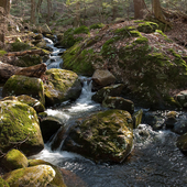
The trail wound its way through some hemlocks and other conifers, with a could trips over some streams. The woods continually changed, going from conifers to hardwoods and back. For the most part the hike was rolling ground, with only 150 ft elevation gain over the whole thing. Numerous portions of the trail worked their way along old dirt roads, including one long stretch on Pine Mountain Rd.
After a couple hours of hiking it seemed like we were not making pace to get to the campsite by 7:30. This required us to hustle a bit. Thankfully we were on easy ground and the added pace wasn’t a problem. Unlike the other backpacking trips I’ve done on the AT, there is no shelter, only a tenting site. At first we cruised right by it because there was no sign. The tent area was right at the outlet of a swampy area, with the outlet stream called Roaring Brook. Unfortunately someone else also was out taking advantage of the spring weather and they took the good tenting area on the south side of the brook. While there was plenty of space there we decided to tent on the north side so that we all had some space. The noise of the brook drowned out any noise the other hikers made and it was basically like we were there by ourselves.
The northern side of the brook had much less ideal tent areas, with two mediocre ones at best. The 6+ inches of rain we received the previous weekend had left the ground a bit soggy. Both Ben and Eric’s tent and Chrystal and my tent were able to find relatively dry patches. It is good we brought footprints though. The lack of fire ring required us to get a little creative. We made platform of sticks which we could get our fire started on. This turned out to work well. Our little fire lasted well into the night.
The next day was a beautiful morning with birds singing and the sun rising over the bog. Again the weather was cool, perhaps in the low 50’s but perfect for hiking. After a leisurely start we got moving around 10:40 am. We continued south and came across more hardwood forest and old roads. Two interesting finds were an old homestead. The foundations being the only structure left. Given the size of the trees that were growing out of the what would have been the basement floor, it must have been nearly 100 years since the structure was gone. We also came across Indian Council Caves. Not a real cave but simply large boulders that had fallen off a outcropping of Rowe Schist. It was still impressive and easy to imagine Native American elders having meeting inside the ring of boulders.
Continuing on we crossed some more minor roads until we made it back to Rt. 219. The weather had heated up a bit by that point and we were hungry for some food. But we didn’t consider that we were in small town CT and it was Easter Sunday. The town of Collinsville was all but shutdown. None of the places I was able to find in my phone were open or in business anymore. Luckily Eric and Ben found a pizza place that was open. Some sausage and mushroom pizza finished up our nice little early spring backpacking trip. Chrystal had lots of fun and hopefully she can go on the larger trip I have planned for later in April.