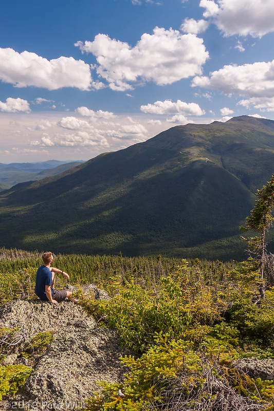
Me basking in the sun near Mt. Madison with Mt. Washington in the distance
Sikorsky decided to give us some furlough days again this year as a cost savings measure. While it isn’t great getting a pay cut it isn’t really noticeable since they take it out of our paychecks through the whole year. This year with Independence Day being in the middle of the week they gave us Thursday and Friday off, which it doesn’t take a great mind to figure out that for two vacation days you could have a full week off of work. This was my plan.
Going into the weekend I had plans with Eli to climb in North Conway. He fell through but not without some good reason. My next option was Jesse and I figured this would be a lock since Adrienne was away in France. He pulled out Thursday citing a rest weekend. Finally I asked Eric if he’d like to do an impromptu Presidential Traverse. Our attempt last year was unsuccessful and we were hoping to finish this accomplishment. He gave me a tentative yes but said he’d let me know Friday. A Presi-Traverse is not something to be taken lightly but I figured we were strong enough and organized enough to pull it off last minute. Unfortunately Eric bailed as well and I was stuck with no plans for the first weekend of my week off. I decided to head to the Whites anyways and do a multi-day hike centered around photography. …
Friday night I finished packing and with better judgement decided that I wouldn’t hike into the Osgood Tentsite in the dark. It was a long drive, I was leaving late because of the additional packing that I had to do with these new plans and ultimately I calculated I would be getting into my sleeping bag around 2am if I hiked up in the dark Friday. So I went to my parents’ place in Manchester to sleep and then headed up to the Whites Saturday morning. This also gave me ample time to get food.
I left the Great Gulf trailhead around 10:30 am and headed up the trail to the Osgood Tentsite. When I arrived at the site there were no other campers to be seen. This site has 5 tent platforms so I chose one of the first ones and pitch my ultralight 2 person tent. This proved a little more time consuming than I expected given that it was on a platform. I’d prefer to have a site on the ground. After setting up camp and dropping most of my gear I decided to head up the Osgood Trail to see how long it would take to get to treeline. My plan was to get up before dawn Sunday and get above treeline for sunrise. From the tentsite it took me 1:10 to get to treeline. The last 3/4 of a mile is tough and goes up steeply. Once up into the free air I was cooled by a nice breeze and enjoyed the puffy clouds. I’ve been doing a little bit of weather reading and noticed these clouds were a result of daytime heating and convection in the atmosphere. The clouds were not building vertically though so I was confident there wouldn’t be any rain. I headed back down to camp to get eat dinner.
Once back at camp I met an AMC group which had 6 12-14 year old boys out for their first wilderness camping experience. I chatted with the leaders a bit while we all made food. Speaking of food I brought two freeze-dried packages off backpacking food. This was because I had them handy and they are light. Recently I’ve been tracking my calorie intake and expenditure. Not so much for weight loss/gain, but just out of curiosity. While recording my meal I saw that the package of lasagna I was about to eat supposed to serve two (it very easily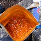 served one) and the whole package was only 620 calories! This is a paltry amount of fuel. Depending on the difficulty of hike and how much weight you carry this could be a single hour of hiking. I was very surprised at the lack of calories in these backpacking foods.
While getting ready for bed I met a nice group of three hikers, one thru-hiker and two of his friends-a father son team. These guys pitched their single one man tent next to mine and both crawled inside. I didn’t look but I can’t imagine how cramped it was in there.
The alarm went off at 3:20 and I was up and on the trail in under 15 minutes. I thought some rest and cooler temps would make the hike up to treeline easier–it didn’t. Though the temps were cooler somewhat it was more humid and I was quickly dripping sweat in the darkness. As I got closer to treeline the fast coming dawn started to light the trail and I was able to switch off my headlamp and finish the last few hundred yards without it. I was able to set up just in time and caught the first rays of the sun at exactly 5:00am.
Recently Lightroom, my photo management and editing software, started supporting 32-bit HDR images. I looked into this new feature and found out that my haphazard HDR attempts prior to this were going to get much better. The new functionality really makes it easy to edit HDR images right in LR4, just by using the usual sliders. See this article for more information. With my new HDR capabilities in mind I took many shots of the rising sun and surrounding mountains. I’m really happy with the results.
After the best light went away I relaxed and had some breakfast before making my way up to the summit of Mt. Madison. From the summit I headed over to the AMC hut in the notch between Madison and Adams. I was hoping for a little extra breakfast I could score for free. I was un luck and since I showed up to the hut around 7:15 am I only had to wait about 30 minutes before the crew put out a plat of blueberry pancakes. I quickly grabbed four and headed outside to enjoy the sun. I ended up grabbing two more before I left too.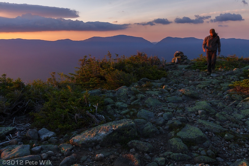
From the hut I headed up to Mt. Adams, but not by the Star Lake Trail. This trail was part of our traverse attempt and we quickly realized that it isn’t the best way up Adams from the hut. it is better to take Airline up. Once on the summit I again lounged around. Since the best light of the day was gone, even with HDR for the most part, I wasn’t in a big rush to go anywhere. While on the summit I did notice the clouds and that they were quite different from the ones I saw the day before. These were bigger and shrouded the summits more, and it was earlier in the day. I had a feeling that the scattered storms that were forecasted might actually happen.
Taking this information lead me down the Star Lake Trail to the Buttress Trail which eventually leads back to the Great Gulf Trail and finally back to Osgood Tentsite. The Great Gulf is a national wilderness area, or at least that is what I think its called. This means that all trails within it are minimally maintained. The Buttress Trail is one such trail. I headed down over talus and krumholtz for a while an eventually made it into the trees. From here the trail pinched up and involved pushing through branches and hopping over downed trees in some spots. It was great fun, though I was acutely aware of the fact that I didn’t and wouldn’t see anyone on that trail. An injury out here would mean self rescue, not an insurmountable task, but dicey. I was careful and made it through just fine. Along the way I also found some nice backcountry campsites that aren’t on the AMC maps. I might have to visit one of them in the future.
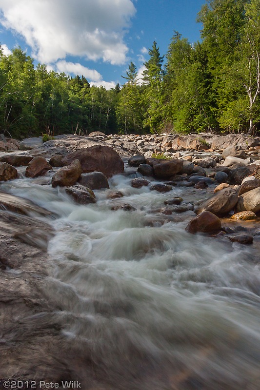
Just before joining the Six Husbands Trail I traversed another talus field and got my last good look at the sky. it was certainly clouding over much more, and the clouds over Washington and Adams were obscuring the summits. I definitely didn’t want to be up there. Following a stream down the Great Gulf Trail I made contact with my AMC group friends again while they were eating lunch. They said they were headed up the Great Gulf Trail as far as they felt like then back to camp. I bid them goodbye and headed over a couple stream crossings about half a mile from Osgood Tentsite. At the last stream crossing I felt some rain drops. Since I knew I was no more than 20 minutes from camp I started motoring despite my fatigue and the heat. This proved to be a good idea. It started to rain a bit more just as I rolled into camp.
In camp I met another hiker who would be sharing my platform. I quickly tossed my stuff under my tent vestibule just before it really started to rain. I helped my neighbor get hit tent up so it wasn’t too soaked. The rain turned out to be good for me since I was able to wash off a bit in it. The rain cleared after 20 minutes or so and the sun came back out which allowed us to dry some things.
Another thru-hiker, Whistler, soon joined my neighbor and I. He was from Virginia and had left Georgia on March 11 and was already in the Whites. He expected to finish up the last 300 miles of the trail in about 3-4 weeks–no too bad. We all chatted a bit before making our dinners and rolling up in our tents.
 Monday morning I had few plans and slept until 6 am, which considering that I went to bed at 9:30 was quite nice. I packed up leisurely and after some goodbyes headed back out by a slightly different route back to my car. I took a few more photos along the way and even got some good ones.
Once back to my car I headed down Rt. 16 to North Conway for some breakfast and calorie rebuilding. After that I headed to Rangeley, ME to visit with my parents for a couple days.