April 23, 2023
Keeping the winter vibes and skiing theme going, Carly and I headed south to tick off a ski zone that I’ve wanted to explore since reading about it in the Utah ski guidebook. The main allure of the Henry Mountains is their status of some of the most remote and undisturbed terrain in Utah. The Henry’s are about 34 miles south of Hanksville, UT, pop. ~160. According to the Wikipedia page the Henry’s were the last mountain range to be mapped and named in the lower 48 around 1872. They are located east of Capitol Reef NP and the La Sals.
Checking the weather we decided that the better day of the weekend to ski would be Sunday. Friday afternoon we packed up and headed to the Swell for some climbing. We haven’t been down there in a while, perhaps a year even since I’m not sure we went there in the fall last year. The temps were on the cool side and it was cloudy which didn’t make for the best climbing conditions, at least for me. I was too cold to have a good day, but Carly got some good climbs in so it wasn’t a loss. In the afternoon we headed south from Buckhorn Wash across I-70 and then on to Hanksville. The town is the stereotypical intersection of two state roads, a few restaurants and a gas station and not much else.
As I mentioned the Henry’s are remote. Not so remote that there isn’t a road near them, but it is a forest road and this time of year it doesn’t have any recreating by motorized users because the road isn’t clear all the way through the mountains. So it was we found ourselves heading south of Hanksville on a dirt road destined to end in a snowdrift where we’d need to start walking/skinning.
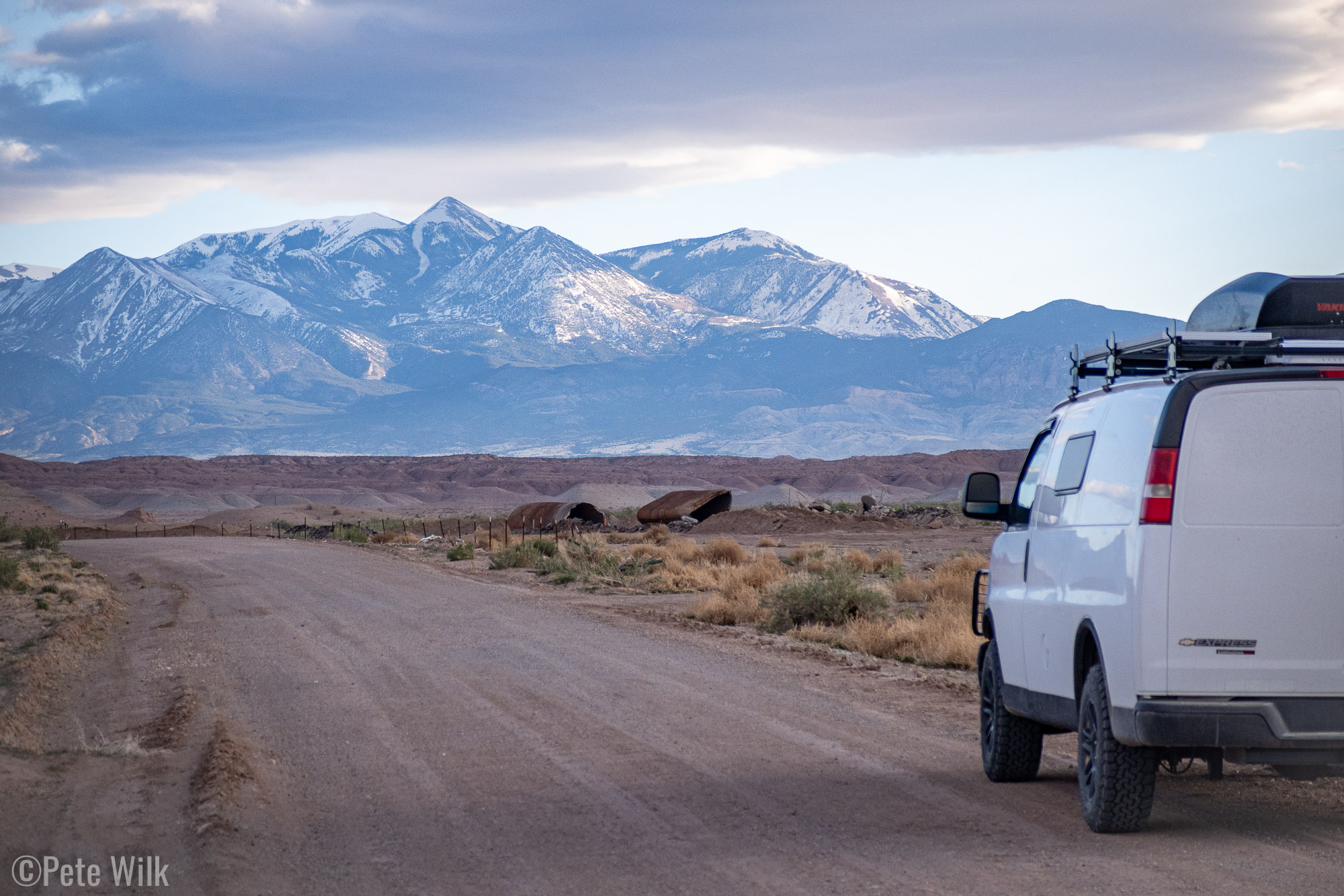
The drive was nice at the end of the day with low sunlight illuminating the landscape. It was only about 100 yards off of the main state road going through town that it turned to dirt. While the bulk of the miles were on nicely groomed dirt as we climbed into the mountains the road slowly deteriorated, getting rockier. As we really started gaining elevation—Hanksville is 4300′ and our eventual parking spot was 7800’—it started to get much slower and muddy from recently melted away drifts of snow. I’d checked a daily satellite website and knew we’d get pretty close to where we needed to be snow free, but I wasn’t sure what the road was like.
As we went from the sagebrush and high desert landscape to pinon pine forest (apparently some of it old-growth) we could see where our objective, Mt. Ellen, but we weren’t sure exactly where we’d camp and eventually park. After cresting a nice flat area of the forest where there were some great camping spots we started descending into some intermittent snow drifts and mud on the road. While nothing was too worrisome, we were aware of the fact that the nearest “civilization” was 30 miles away and pretty limited. Getting stuck on our own wouldn’t have been the end of the world since we had the inReach, but it wouldn’t be ideal. As we got down to a switchback where the road crossed a stream we decided to turn around so we could camp at the nice sites we saw a little way back up the hill. The sites were fantastic, flat and surrounded by pinon pines and nice views of Mt. Ellen.
In the morning we made some breakfast and started driving back down to the creek crossing. The clear sky overnight firmed up all the snow and mud we’d crossed. We went through the stream and through some more snow without trouble since it was firm. One thing we kept in mind is that in the afternoon it wouldn’t be so firm so we had to make sure we could travel in both directions. After another crossing or two we got to what was certainly the end of the road for the van. While the all-wheel drive, good tires, and lift are great, they weren’t getting through 3′ of snow covering the road. After flipping the van around and getting out of the way of any other possible vehicle looking to turn around (completely unneeded since there was no one else that came up that road that day) we parked and started skinning.
I thought for sure that we’d be skinning the rest of the way from there, unlike the Deseret Peak adventure a week prior. As it turned out there were intermittent snow and dirt sections and we hadn’t brought our approach shoes. So we started walking in our ski boots when we couldn’t skin. This continued for a couple miles unfortunately, often bushwhacking on a long abandoned logging/jeep road. Not the most fun. We’d also gotten a late start and combined with our slow progress when we finally got a good view of Mt. Ellen and the ski lines on its east face we were a bit late in the day to be booting up the gut of the line where cornices overhung the ridge. The copious wet slide debris on the lower 1/3 to 1/2 of the line also didn’t seem like a fantastic ski either. So we pivoted our objective, though with some disappointment from Carly.
The ridge to the south that also leads to the summit of Mt. Ellen looked to have some intermittent treed sections and might ski nicely. We started heading in that direction using our GPS and satellite images to try and avoid the densest trees. While there were some pretty dense trees we did come upon some old ski tracks that were coming down. It was hard to say how old they were, but probably at least a week.
As we finally got out of the trees we could see east towards the La Sals where we’d been a few weeks prior to ski. It was a cool sight to see the convolutions of Canyonlands National Park from such a vantage point. We could also see into Indian Creek from a completely unique perspective from the one we’ve had when climbing.
We got a to a portion of the ridge where it was free of snow so we put the skis on our backs once again and started walking. We hoped we could get to a slightly more prominent portion of the ridge which might give a clear view of the long ridgeline of Mt. Ellen. The snow after the rocky patch was pretty unconsolidated and getting sloppy. While not really a stability concern I wondered how well it would ski. We opted to switch over into ski mode and start our descent rather than continuing farther.
The initial part of the ridge was a bit sloppy, but skied better than I anticipated. As we got farther down the ridge where it had more time to consolidate the skiing was pretty good corn. This section went by way to quickly though and we found ourselves trying to piece together skiable sections of ridge separated by dense trees. While it was pretty dense in spots it was never terrible to get through. We slowly wound our way back towards our up tracks thinking we could ski a little more down than we did on the way up. At some point we skied all the snow there was to ski and we started walking again the couple miles back to the car.
We didn’t have the most epic ski day on Mt. Ellen, nor did we get even close to the summit, but it was still a fun day with great views in a remote section of the state. I’d be up for going back another time with the hope of getting the summit and doing less walking in my ski boots.


