May 8-9, 2021
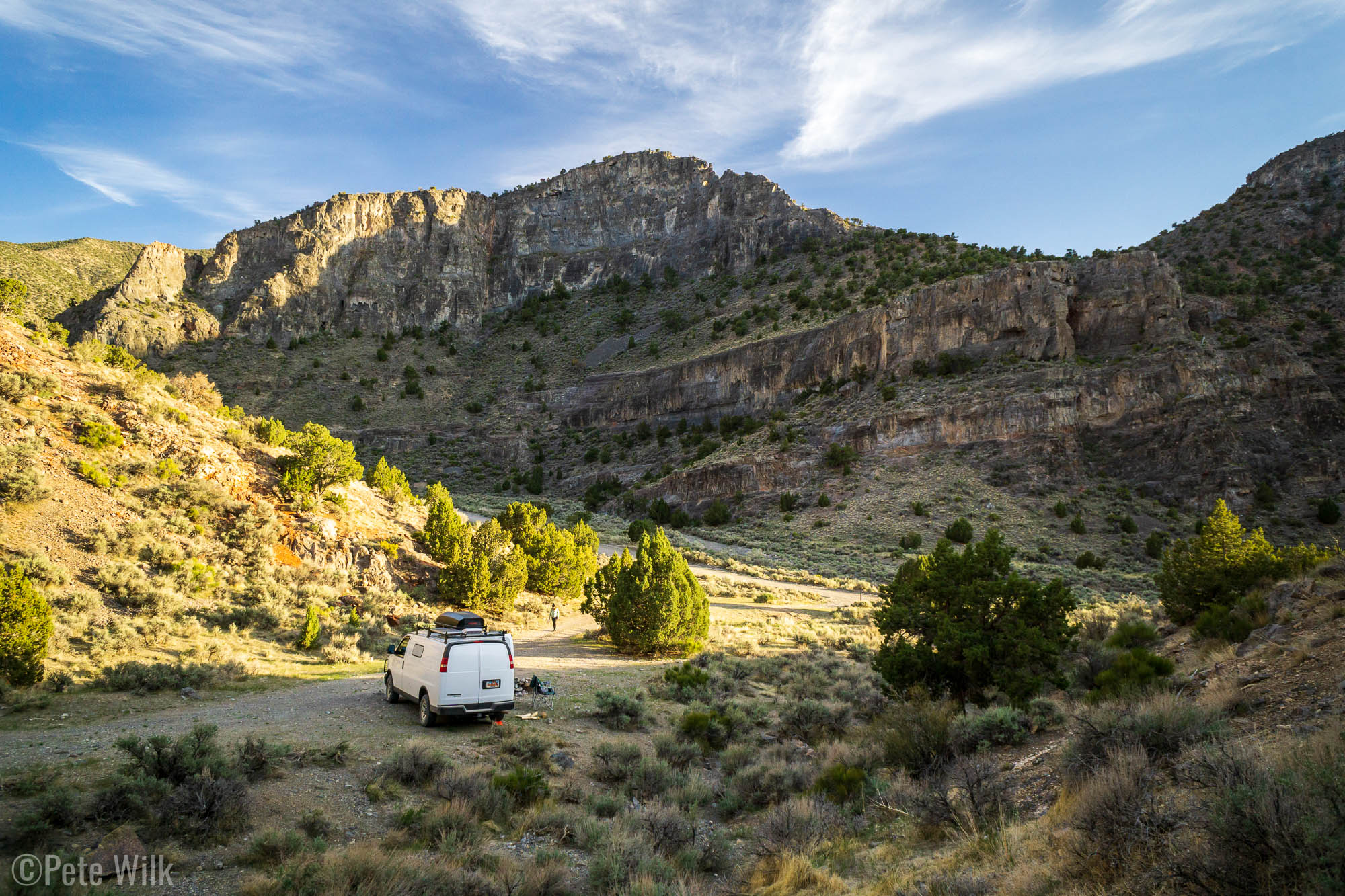
Another weekend and another exploration to an area of Utah for us. The West Desert of Utah, roughly the entire western half of the state, has lots of land and a dearth of people. Last year at the end of May we visited an area not far from here called Notch Peak. This time around we visited a sport climbing area a little north of there called Marjum Canyon. This canyon passes through the Middle Range Mountains, so called because they are between the House and Swasey Ranges. The canyon is composed of limestone and quite a bit of it in fact.
The canyon is approached from the same main road from Delta, UT as going to Ibex or Notch Peak except you peel off onto a dirt road for 20-30 miles before either of the former locations. The dirt road runs through the canyon to the other side of the mountains. The road used to be the old Rt. 6 and Rt. 50 highway. By old I don’t know how old, but since the road is all dirt, it must be quite old. One interesting feature, which I didn’t get pictures of is there is a “hermit’s cabin” a little way off of the main road. According to the guidebook this cabin was inhabited while the highway was in use. The caretaker would repair the road and provided lodging for travelers on the old highway. It is tough to imagine driving in a Model T or other such ancient automobile on these dirt roads. Even in today if you broke down it might be hours or a day before someone else drove by.
The guidebook for the area has most of the climbing in our sweet spot of easy to 5.11 range, all bolted from what I remember. Saturday we climbed in the easy to approach Hermit’s Canyon area which is where the main camping is. Unfortunately while the area is quite remote, there was a group of about 10 post college millennials here for a Burning Man-esque party, including music. They were friendly enough, but once they cranked up the music we finished up our routes and headed out. We were able to get a nice camp spot one side drainage up the road and could only barely hear the bass from their rave.
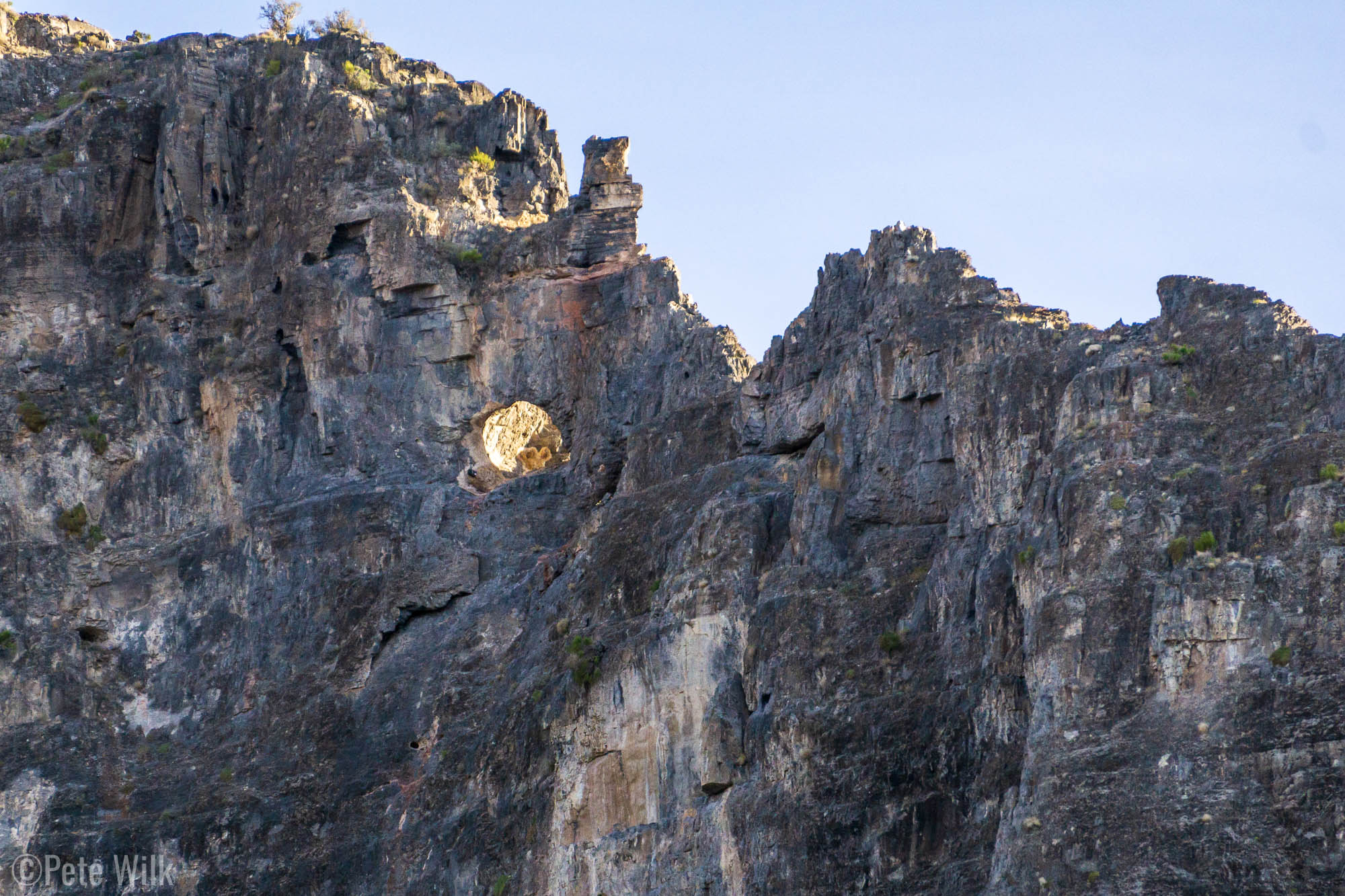
Across from this camp spot is one of the classic routes of the area, Eye of the Needle (5.10). The route goes up two pitches to a large hole in the wall. The route then goes through the hole to the other side of the rock band then up to the ridge in another short pitch. Since the area get so little traffic there’s little to no approach trail, despite what Mountain Project or the book says. We did see a party of climbers on the route Saturday so we’d hoped to follow their footsteps up the steep slope to the base. While we did find some general sections where others had traveled it is largely cross country travel on steep and often loose ground. Fortunately even so it is a 15-20 minute hike, not that long.
The first two pitches are pretty similar in nature and both ~25m. The route goes up some nondescript features on usually good holds and is slabby and crimpy. A few sections on the first pitch were interesting in that I found myself going up a move or two, then down left, then directly left for a few moves to get between stances. I believe it was drilled on lead and so all the clips have some kind of stance. Carly lead the second pitch which ends at the Eye.
I’m not sure of the geology, but the eye seems to have formed due to some kind of crystal deposits in that area that were more prone to breaking and erosion. In the pictures you can see the pale inclusions in the gray limestone. One interesting thing is from the climb’s side you’re 70-80 m off the ground, but when you walk through the eye, that side is only 10 ft off the ground. We moved the belay there and had some snacks. The third pitch is quite short and has 4 bolts, but is much steeper, but juggy and textured. The final fifth bolt is in the summit block. I opted out of connecting to the block since it seemed unattached, though completely unmoving when I tested it. The top of it is the size of a kitchen table. We signed the climb’s register, which is the original from when the route was first completed in 2004, then rapped off.
The amount of limestone cliffs in the area is quite amazing and it is too bad there isn’t more development as I imagine there would be nearly endless 5.moderate to 5.12 in the area, mostly of a crimpy technical style. The area reminds me a little of a desert version of limestone cliffs in Europe that I’ve seen. I think we will go back again at some point and explore some of the other cliffs we didn’t get to. It is a quiet spot and yet one more beautiful zone in Utah.

 was a great route. It is mostly slabby with mostly good holds. A few runouts but nowhere too scary.")


