For a while I’ve been hoping to get a smaller ADV bike so that I could tackle harder terrain with Andreas. The popular trend has been a bit in the other direction. Guys doing gnarly roads/trails on big ADV bikes like the 1200GS, 990 KTMs, and the like. To be honest I’m not really sure why the trend is in that direction. Perhaps because those bikes have tons of tech, power, and they are expensive, perhaps there’s a status symbol of it. However, trying to maneuver a +500 lb motorcycle, before luggage, through miles of rock garden gravel road and deep sand is a ton of work and really hard. Not that it can’t be done on those bikes, there’s no shortage of highly skilled guys on YouTube who will show you what to do.
However, it is way easier, faster, and more fun to do them on a small ADV/dual sport bike. In this case even my 650GS is “big” at 425 lb. I’m talking about a 250cc dual sport dirt bike. Street legal, loads of travel and weighing in around 275 lb. Andreas decided to pick up a new bike for Kasi which mirrored his Yamaha WR250. That left Kasi’s Kawasaki KLX250S in search of a new owner. So I bought it off them.
Riding in Vegas and in Ocotillo Wells was a great intro to the bike, but Andreas had a big ride planned that would really get me broken in on the bike: four days and three nights around Death Valley National Park.
- Day 1 – 142 miles, gas in Beatty, NV
- Day 2 – 125 miles, gas + water in Furnace Creek Death Valley
- Day 3 – 146 miles, gas + water in Panamint Springs
- Day 4 – 55 miles
- Total ~460 miles
Day 1 – 142 miles
I drove up from Lone Pine, CA in the morning to meet Andreas who was coming from Salt Lake City on Friday, April 27. We unloaded the bikes and geared them up with overnight gear, food, tools, and a few spare tubes. The vast majority of the ride would be on dirt, which is good since these little bikes struggle to do 70mph on the pavement. The planned route was remote, much of Death Valley is once you venture off the few paved roads in the park. Our tally would be about 290 miles on dirt and 176 miles on pavement, roughly 60/40.
For the first 35 miles or so we enjoyed twisty pavement into the White Mountains which a few years ago Carly and I used to escape the heat of the valley by visiting the Ancient Bristlecone Pine Forest. During that drive in the van I thought the road would be a great motorcycle ride, and indeed it was. Tight, twisty and lots of elevation changes. There are a few devious corners though so keeping the speed reasonable was necessary.
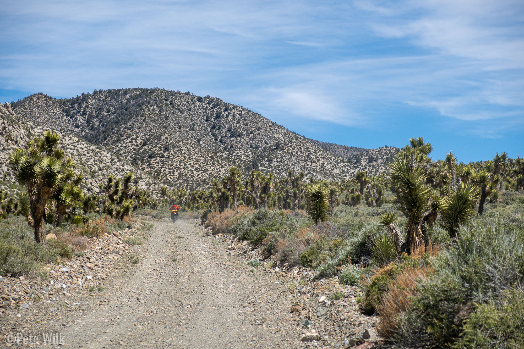
Views were good along the road and through one stretch we went through a massive tumbleweed drift. It almost looked as if they had to plow the road to clear the tumbleweeds out of the way since they were piled into “snowbanks” on the sides of the road. Off the pavement we started traversing some nice Joshua tree forests via some well maintained gravel roads. As we transitioned from the J-trees into more rocky terrain we got a glimpse of the fractured and aggressive geology that makes up much of Death Valley NP.
I did bring the drone along, despite much of the area we’d be traveling would be off limits to flying—either national park or Wilderness—but I was able to use in in a few areas. It is a bit of a pain to deploy on these types of ADV trips. I have to pull it out, set it up, launch, make sure I have enough satellites, etc. All this takes 5 minutes or so to do. On my first attempt I tried having it follow us through a section of Joshua trees, but for some reason the altitude following wasn’t working. As we slowly climbed on the road the drone stayed at the same altitude, therefore getting closer to the ground. Eventually it collided with a bush (better than the rocky road). Thankfully the damage was minimal and I could still fly it, though some repairs would be needed once I was home. In the end I gave up on trying to use the tracking features and flew it manually, therefore just Andreas riding—which is more exciting to watch anyway since he’s a better rider.
One stop we made was in Goldpoint, NV which is a dying mining town. According to the barkeep we ran into, who was definitely trying to get us to spend some money in his bar, there’s only eleven people in town. Despite that the bar is enormous and looks like it has some wild nights at times at least—I assume based on the number of ladies underwear draped throughout.
Aside from one section through Cucomungo Canyon the riding was in wide open areas with good roads. As the day waned we checked out some mining ruins, the first of many. Andreas had seen on the internet that the section of the NV BDR that we’d planned to take was just miles of straight dirt road with whoops on it. Having done plenty of whoops in Ocotillo Wells, I didn’t think miles and miles of it would be sweet so we opted to take pavement on Rt 95 into Beatty. While this wasn’t all that exciting, other than getting passed by other vehicles on the road while they went 75 mpg and we topped out around 70, it turned out to be good since our dinner in Beatty took way longer than it should have at Happy Burro Chili and Beer. While it was fine (don’t plan on getting anything other than something with chili in it) it took a while and the sun had just set as we rode out of town on some old mining RR grades to where we’d camp.
Day 2 – 125 miles
We woke with the sun and headed to the nearby ghost town of Rhyolite. The town was a classic boom town springing up in 1904 from a gold strike nearby. Within a year buildings and infrastructure had sprung up. In 1907 it housed 5,000-8,000 people along with 50 saloons and all the other necessities of town life. Lackluster results from the mines caused the town to dwindle quickly and residents to move on. We explored the remnants of the buildings, in surprising levels of decay, for an hour or so before moving on to the nearby art installation.
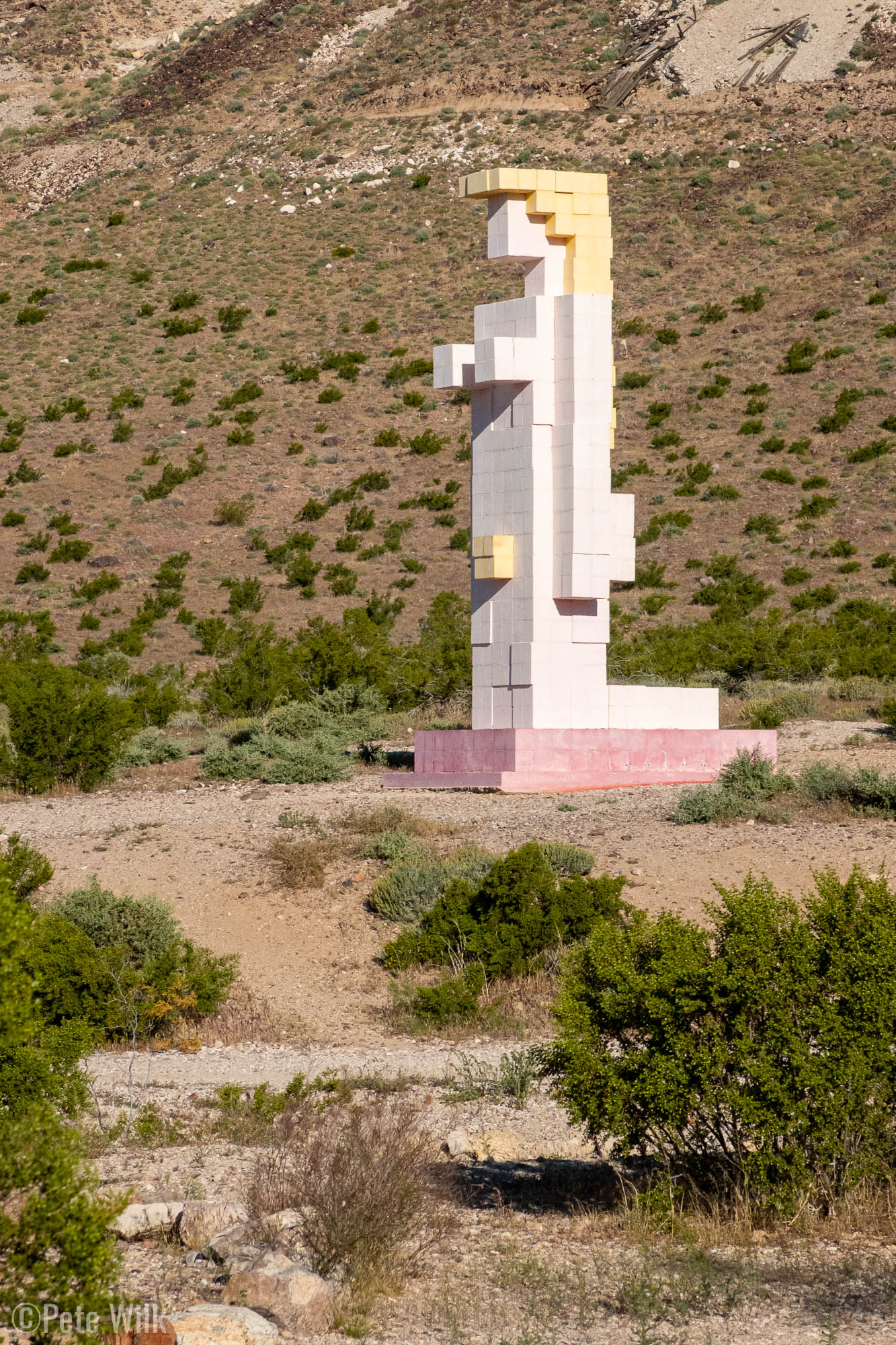
The art installation, Goldwell Open Air Museum, has some sculptures from a few artists mainly Europeans. Some of sculptures were interesting. I think my favorites were the shrouded figures, the steel origami swan and the Pink Lady otherwise known as Lady Desert The Venus of Nevada.
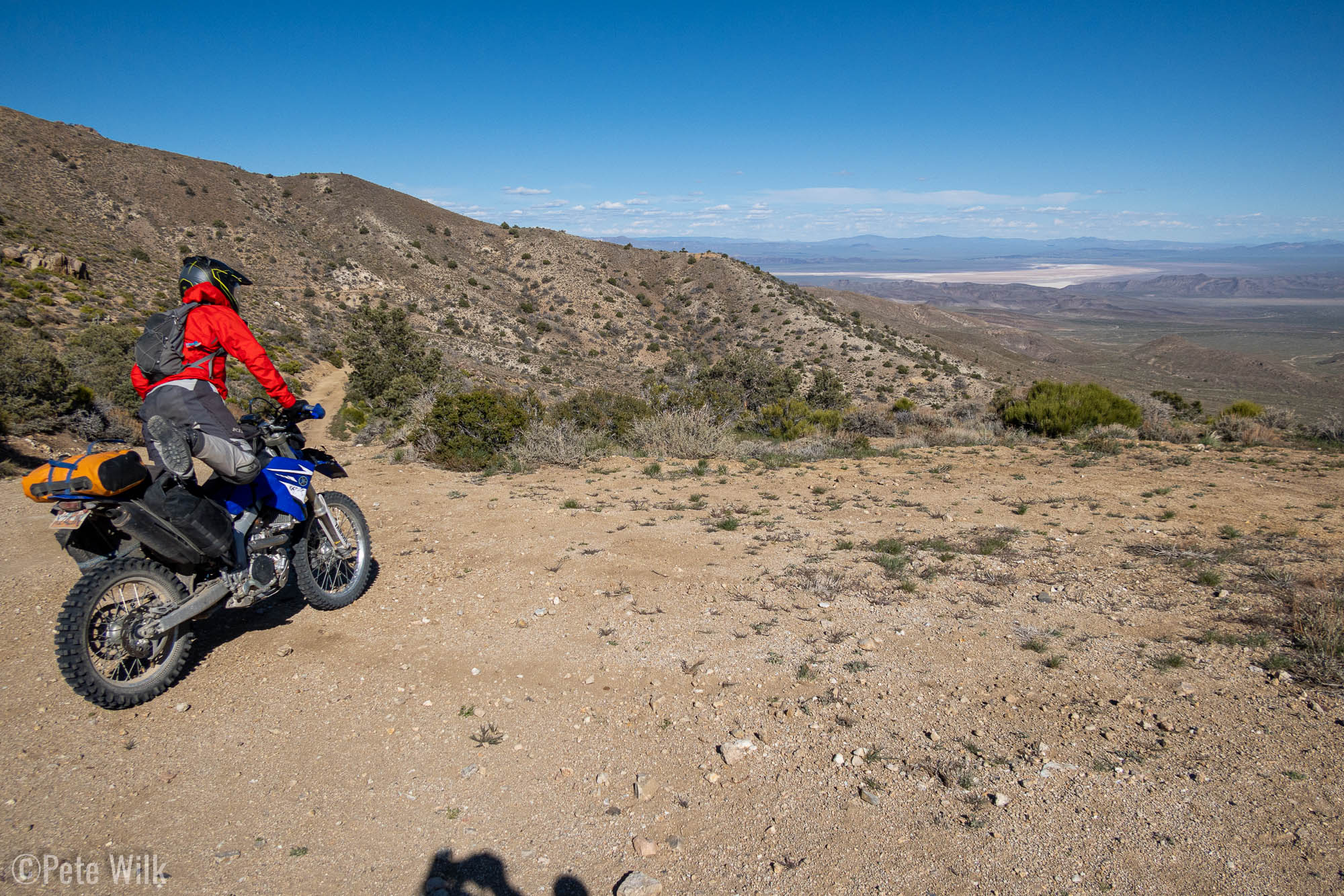
After the art we made a quick stop in the Rhyolite Cemetery before heading on dirt to Chloride Cliffs for our first look down into Death Valley proper. From the cliffs there is over 5,000′ of relief to the bottom of the basin. Meandering down the dirt roads from the cliffs we visited a few abandoned mining sites along the way before picking up pavement on Daylight Pass Rd (Rt. 374) to get into Badwater Basin. We lost over 5,000′ of elevation in about 20 miles.
In the thick air of Badwater Basin we cruised pavement to Furnace Creek to gas up, our most expensive gas of the trip at around almost $7/gal. Thankfully when you’re only putting in 2.5 gal it doesn’t break the bank. The relief of Death Valley along with the aggressiveness of mountains is different than many areas I’ve been. The minimal rainfall, except for flash flooding events, leaves the escarpments of rock in a craggy, broken nature. The varied geology also makes it that way. There’s definitely no climbing worth doing there, but plenty of interesting geology.
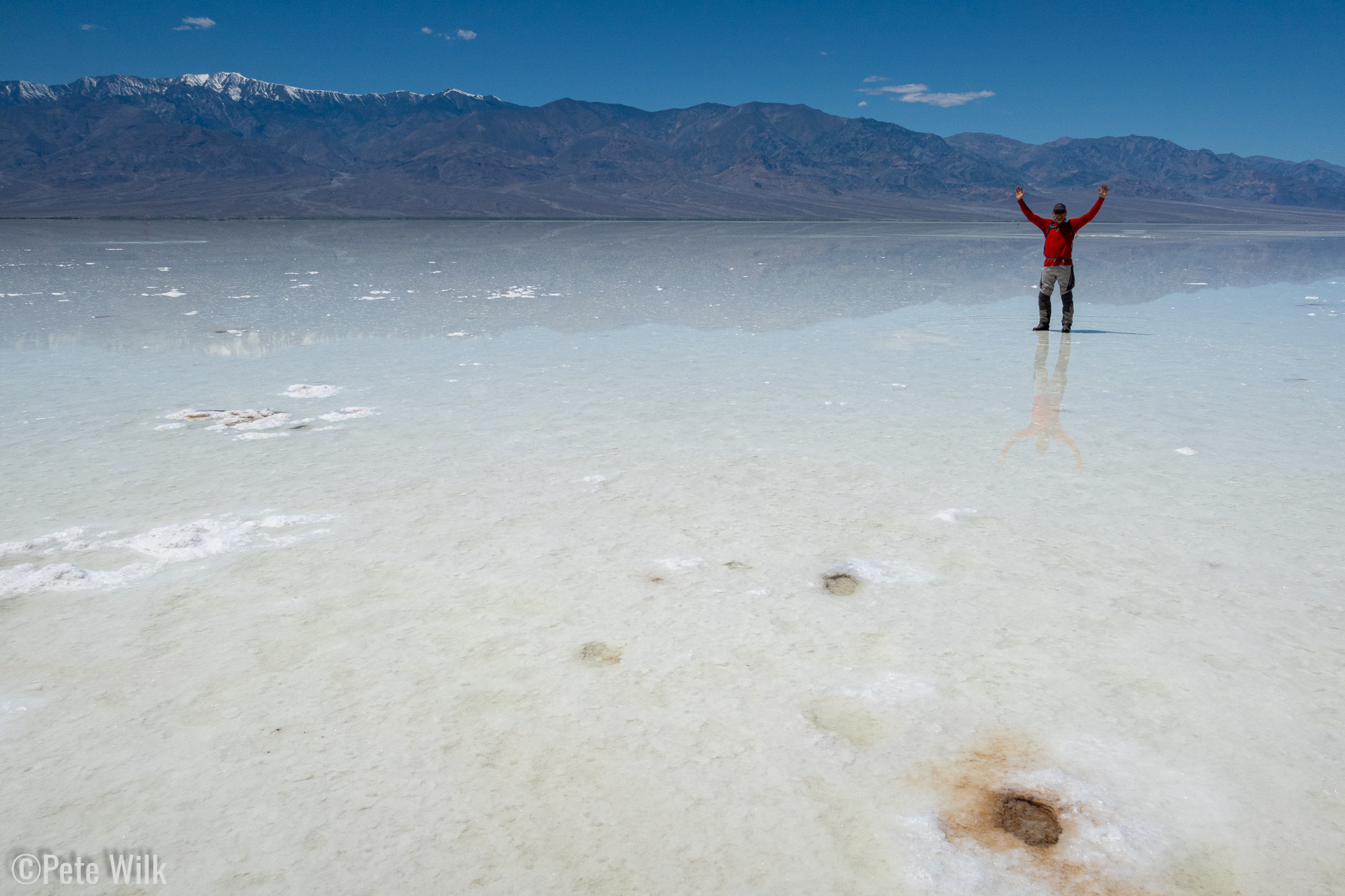
The heavy rains this winter flooded Badwater Basin and filled Lake Manly, which is normally a hard salt pan. The rain also led to a super bloom of flowers. Nearly everywhere there were yellow blossoms. While I wouldn’t compare them to the wildflowers in July and August in the alpine, they were quite impressive and beautiful considering they were in a desert with minimal other plant life.
We took a walk out to Lake Manly, a soggy affair in spots. The distinction between mirage and actual water was hard to detect, it was mirror smooth. The water was deep enough to kayak in earlier this year, but was now only inches deep, even hundreds of yards out. Looking up over 11,000′ at Telescope Peak, with snow on it, while we were in 95F temps was impressive. Badwater Basin sits at 282′ below sea level—lowest in North America. Lake Manly was one of the highlights of this trip.
South of Badwater Basin pullout the road had a lot less cars and we eventually pulled off the pavement to head west on Butte Valley Rd. The initial parts of the road were unappealing, rocky, gravelly, and generally not super fun. The alluvial fans extending toward the bottom of the basin are filled with an array of rock types and sizes. These fans aren’t formed gradually, they form when monsoon rains come through and cause flash flooding and flushing of the mountain canyons to the valley floor. Eventually after 10 miles or so we started to climb in elevation and get out of the alluvial fan material. The route included a few more mine stops along the way including the Warm Springs Mine which extracted talc. It was big enough to drive a car down, but had a gate across the entrance only allowing walking access. It was surprisingly large and deep. Andreas explored a little of it by headlamp, but I stayed close enough to the entrance where I could see from natural light. The owner of the mine, a woman named Louise Grantham, had a camp built nearby at a spring. The house was still in good shape considering, people passing through must keep it from falling into completely disarray. It even had a swimming pool. However, it sounds as though she was a tough business woman, likely having stolen the land from a native american named Bob Thompson.
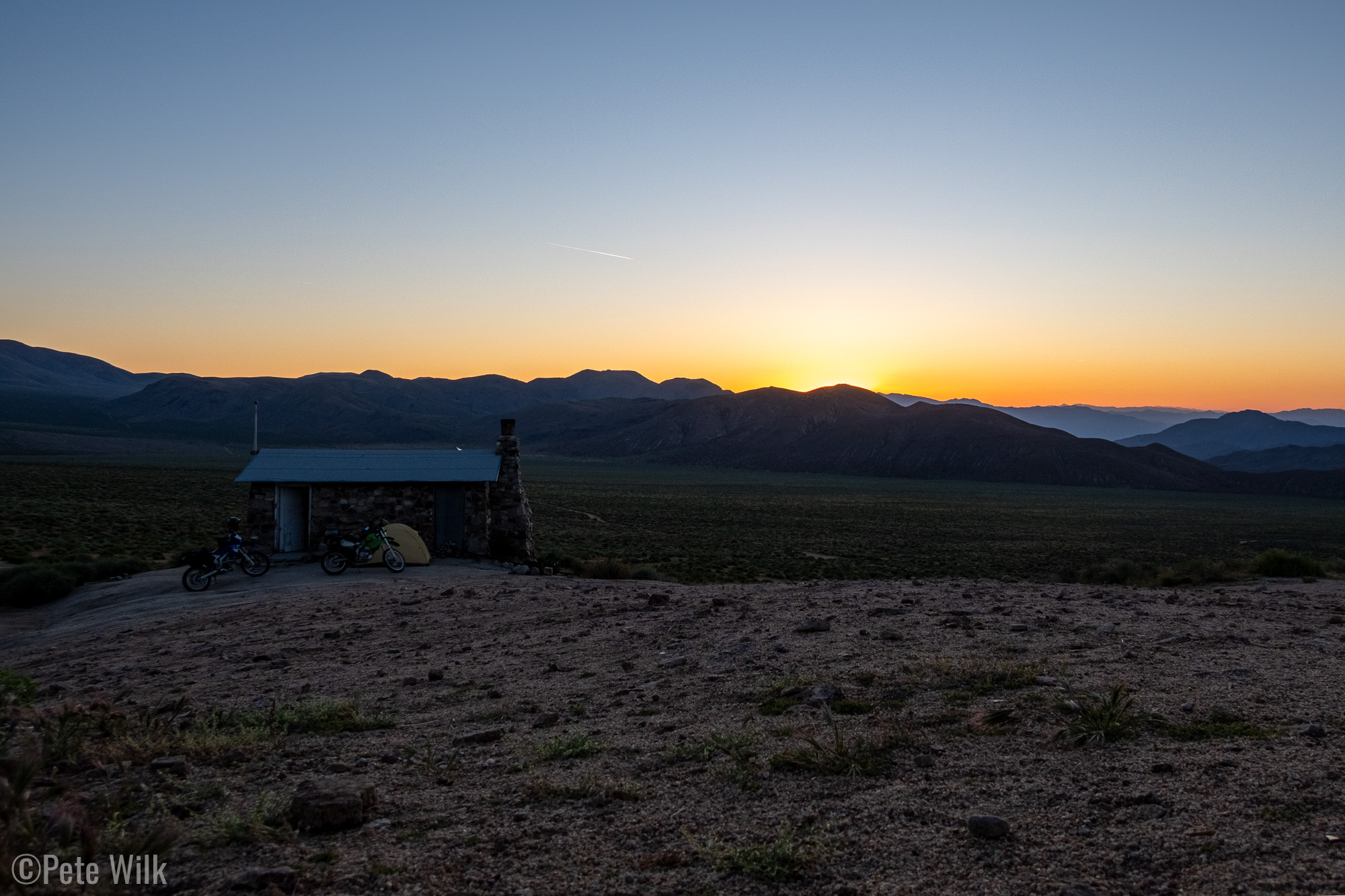
Continuing along the canyon opened up into a wider valley with a really cool formation called Striped Butte. The formation is a hill protruding between the nearby mountains and is comprised of dozens of layers of what seem to be completely unique rocks for the area. Near the west end of the valley we arrived at the Geologist’s Cabin, which would be our camp for the evening.
The Geologist’s Cabin is a rock house, including outhouse near a spring. The cabin is in frequent use by overlanders and motorcyclist’s like ourselves. Its one room houses some books, games, puzzles, sink, table, and chairs. People often leave cans of food or other items in a cooler for others to use. This was a nice cool spot for the afternoon and evening since all of our other options would be at lower elevations. After unpacking a bit the driver of an 1980’s Suzuki Samurai arrived to say hello. He mentioned he was staying at the Russel Camp a not far away and we should come by to check it out.
We set up our tents, sleeping inside didn’t seem like a good option between the close quarters, crickets, rodents, and chances of Hanta virus. Then we rode around to check out some of the other mining ruins in the area as well as check out Russel Camp. Russel Camp is tucked way up a little drainage and impossible to see until on the approach road. There we met Eric who was quick to supply two of his last cold beers from his 4×4 Sprinter—he trailered the Samurai for off-road exploring. He was a friendly guy and has been coming to the camp for many decades. The camp itself has a bunch of buildings, some in decent shape, others in disrepair. One really nice feature is the area with the fire pit has water piped from the spring running into a basin creating a tranquil spot in the desert. Trickling water, lush vegetation, and a great view into the valley—its easy to see why Eric had been visiting there for so long. After bidding Eric adieu we returned to the Geologists Cabin for dinner and sleep, at least as much as we could get with the rowdy burros making noise all night.
Day 3 – 146 miles
Up again with the sun we packed up and headed toward Mengel’s Pass. The road to the Geologist’s Cabin had been non-technical and fairly easy. Mengel’s Pass had a steep rocky section before getting to the 4,300′ pass—and it came just two miles from the cabin.
Of course Andreas cruised up the worst of it while I bumbled it and ended up stopping part way up the hill. This required a little help to get going again, but I was able to get it in “two hangs” as we’d say in climbing.
On the west side of the pass we encountered some rocky loose riding. We needed to look out for possible eroded rock steps, which never ended up being an issue. Heading downhill is a bit easier since traction and losing momentum isn’t as much of a concern.
There’s also a number of springs and cabins on that side of the pass. The most notable is Barker Ranch, where in 1969 Charles Manson was arrested. In the 55 years since then the ranch experienced a fire and only the stone walls remain. Nevertheless it is understandable why Manson headed there, it is many, many miles on dirt roads to get there. With sufficient food it would be easy to hideout, especially in 1969.
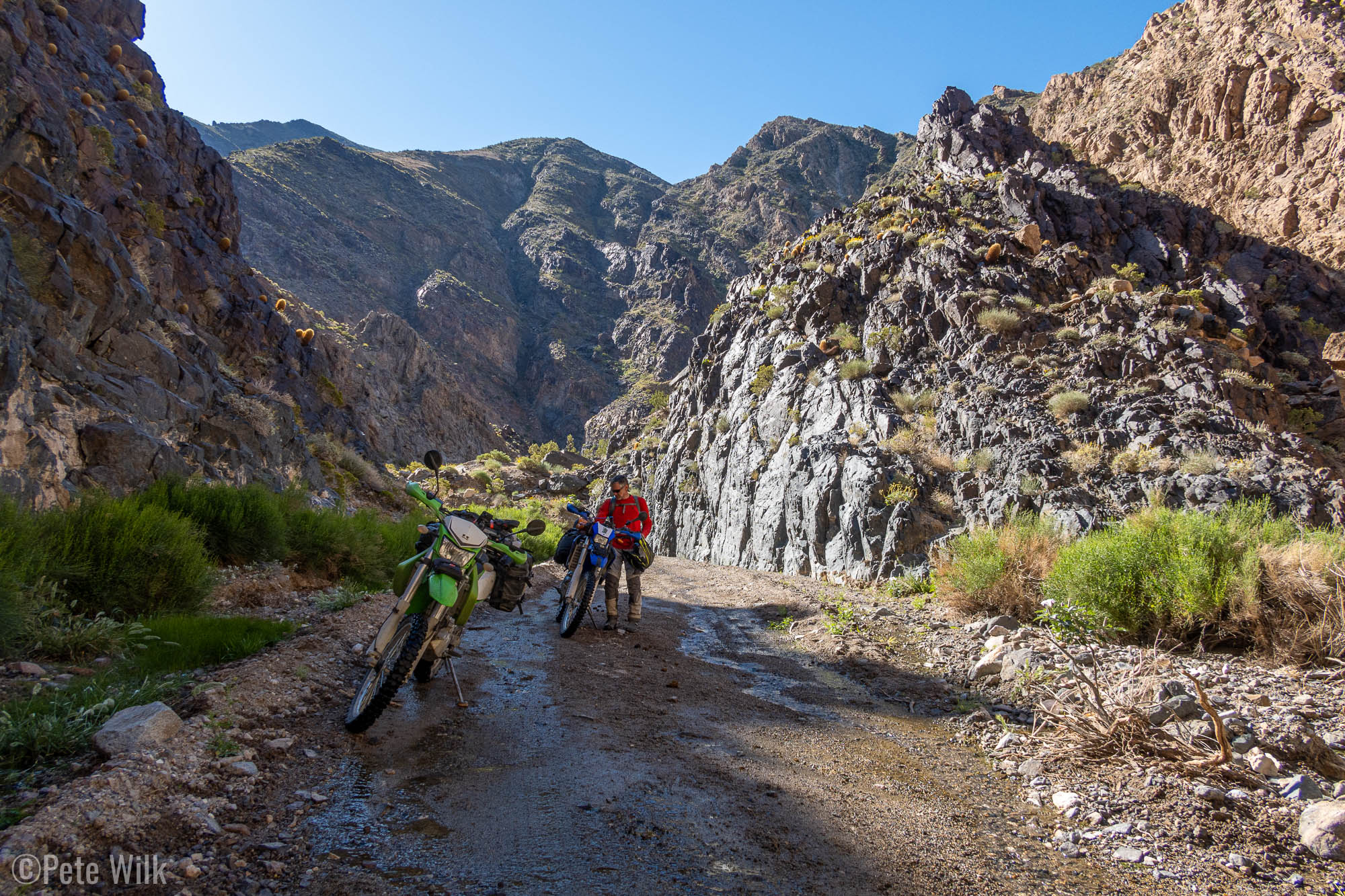
The canyon narrowed at times into little more than a slot wide enough for the road which was very pretty and aesthetic to ride. Eventually we cleared the canyon and headed down more alluvial material to Ballarat which is effectively a ghost town. There’s a few buildings and in the trading post we were able to self-pay and for cold sodas, a nice treat. The town was a supply spot for nearby mines and lots of equipment dots the area. One relic is Manson’s army issue truck stationed out front. From there we cruised some good roads until picking up the pavement on Rt. 190 to Panamint Springs, where we refilled fuel, water, and got hamburgers.
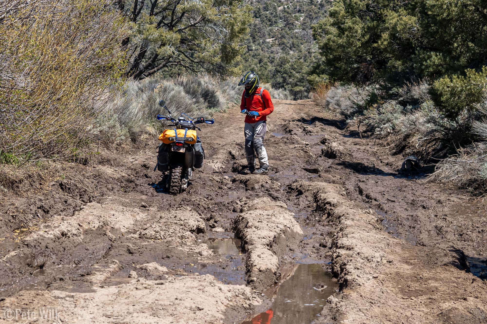
Twisty pavement west of Panamint Springs eventually brought us to Saline Valley Rd. Initially the road was great—flowing smooth dirt/sand. We then headed right at South Pass to try and go up around Hunter Mountain. We saw more water on the road and even went through a little mud in the first couple miles then we hit a big muddy section. Andreas went for it and got caught in a muddy rut. I turned off my bike and helped pull him out. For fifteen minutes we worked pushing and pulling his bike to get it out. The mud depth, suction, and lack of firm places to stand all contributed to the difficulty. We reassessed our options while we walked the road. More muddy sections awaited a head and we weren’t even on the shady side of Hunter Mtn, which the map showed numerous springs near the road. While we did see some big bike tire prints, some with considerably less off-road oriented tires than our own, we opted to tuck our tails between our legs and retreat back to South Pass where we could continue on Saline Valley Rd.
Once in the valley we were again in the heat due to low elevation and lateness in the day. To make matters worse we were again in the alluvial wash material which mainly consisted of loose, rocky, and gravelly road. While annoyingly sized rocks loosely littered the trail there were plenty of embedded larger rocks which needed to be avoided. We opted to take the road we would have come out on had the Hunter Mtn road gone through. This road leads up Lippencot Rd, which is a very difficult 4×4 road. The reason for making the effort was to drop into the hanging valley where the Racetrack is. This is the playa where stones out on the playa leave tracks in the mud.
I was able to make my way up the hill, but needed to take some breaks. My fingers/hands were going a little numb from over gripping the bars, but the super rocky terrain was difficult to guide the bike over with a light grip. Finally we reached the pass and could see down to the Racetrack, which has an easy section of road to view the stones.
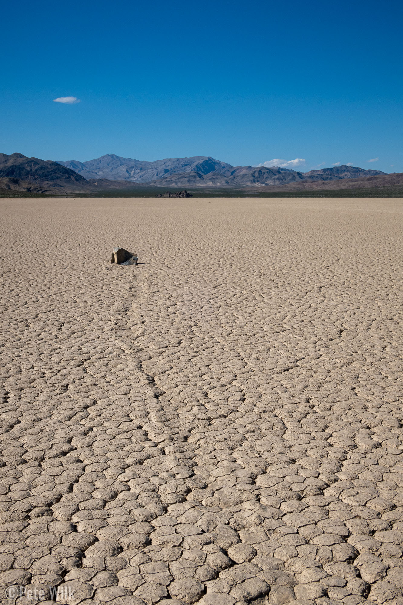
The playa is deceiving since it seems like it would be at or near sea level since it is a dead-end valley with no outflow of water. However, the elevation is around 3,700′. This higher elevation is one of the reasons the stones create tracks in the mud. When the playa gets water it turns it to slippery mud. It was believed that wind pushed the rocks and caused the tracks. However research has showed that ice forms and entraps the rocks. With the rock trapped and somewhat less heavy due to the buoyancy of the ice, wind then moves the ice around and along with it the rocks. Like many of the spots we’d visited there was no one else around and made the experience special because of the solitude.
We saddled back up and headed back down Lippencot Rd. This time around I didn’t need to rest quite as much since we were going downhill. Again we rattled our way out to Saline Valley Rd. I’m amazed we still have fillings and didn’t flat a tire. Eventually we go to some smoother road to checkout the salt tram, though deep sand is only a marginal improvement.
From 1911 to 1913 a 13.4 mile tram was built from the Saline Valley over the Inyo Mountains, reaching a maximum of 8,700′, to transport salt into the Owens Valley. Looking at the tram line rising steeply over the mountains it was hard to believe they spent so much effort erecting the tram. It was all manual labor since there were no helicopters or roads built up to the areas where the tram towers were. Once again a reminder that people back a hundred years ago were much hardier than today.
To conclude our nearly 12 hour day we traversed the west side of the Saline Valley, thankfully the lateness in the day meant we were in the shade, though still low 90’s temps. Our camp for the night would be Warm Springs Campground, a strange place to find in a desert and national park indeed.
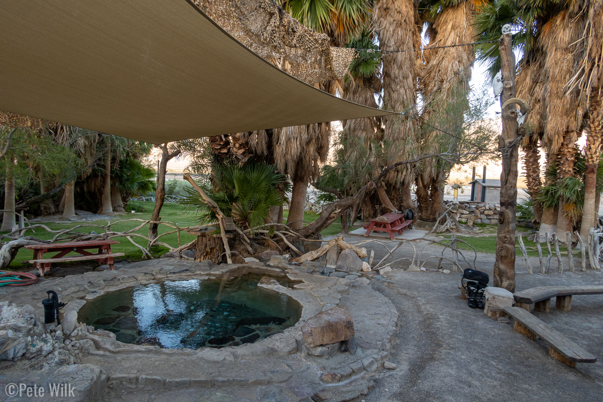
The CG was about 20 miles from the salt tram ruins and thankfully the road wasn’t as rocky. It did have some sections of sand and kept my attention since we’d already been riding for 130 miles already. The spur road off Saline Valley Rd seemed interminably long to me too. But at the end of it was a literal oasis complete with palm trees, lawn, and hot spring pools. Warm Springs originally wasn’t contained with the national park. Hippies and other hot spring lovers made the long trek over many decades and improved the springs to have the palm trees, grass, improved soaking pools. When the park expanded it subsumed the hot springs. We got there as the sun was close to setting and it was a great experience. While soaking in a hot tub doesn’t sound all that appealing when the temps are in the 80’s, it actually was great to clean up (there was an outdoor shower) and the stiff breeze cooled us off after getting out. It was definitely a highlight of the entire road trip. I’m looking forward to a future trip to check out the upper portion of the CG as well.
Day 4 – 55 miles
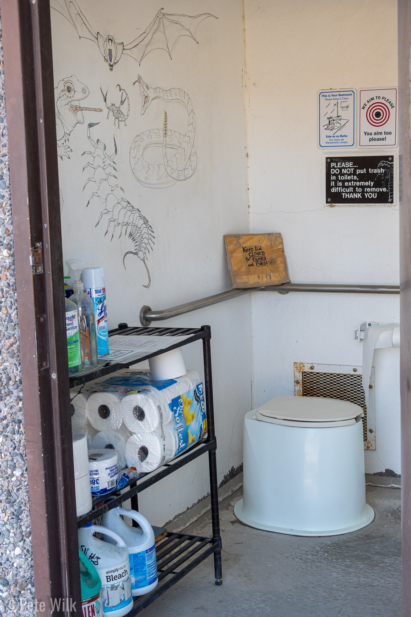
After three days of riding our trip was coming to a close. We had 40 miles of dirt to go before picking up the Death Valley-Big Pine Rd. and back to the 4-wheeled vehicles in Big Pine. Before leaving we did another soak though. Another pleasant surprise at the CG: since it is such a hippie/hot spring enthusiast hangout and not really on the NPS list of maintained places, the standard issue vault toilet was one of the more enjoyable I’ve used. It featured some interesting artwork inside as well as the largest stock of toilet paper I’ve ever seen in a NPS toilet.
Our ride out thankfully was primarily on easy roads, especially as we climbed out of the Saline Valley itself and we found some windy, but flowing dirt. Of course there were a few more mine ruin stops along the way, but for the most part we just enjoyed the scenery. Cresting a rise near the end of the dirt road we could see the snow capped peaks of the Sierra Nevada Mtns coming into view; the final chapter in my road trip.


. Andreas said there used to be a sign saying that it was a mailbox to send letters to aliens.")
.")


 you can see the remains of a salt tram. The tram was built in 1911-1913 to move salt from Death Valley over the Inyo Mountains to the Owen's Valley. It was one of the longest in the world at the time, 13.4 miles.")


